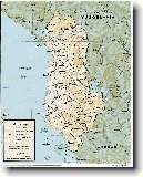
Navigace mapy Celého Světa online: Kliknutím a tažením na mapě Celého světa, nebo použijte zoom kontrol.
Zeměpisná šířka: | 42,3958 (42°23'44.880"N) |
Zeměpisná délka: | 19,7744 (19°46'27.840"E) |
Nadmořská výška: | 833 m |
|
| |
|
|
|
|
GMT čas: +1 hodin | Posun oproti ČR: 0 hodin |
Vzdálenost města Bajraku I Thethit do 25 největších měst státu: Albánie
|
Přímá vzdálenost | Km |
| Bajraku I Thethit - Tirana | 119 km |
| Bajraku I Thethit - Durres | 122 km |
| Bajraku I Thethit - Elbasani | 145 km |
| Bajraku I Thethit - Vlore | 216 km |
| Bajraku I Thethit - Shkoder | 42 km |
| Bajraku I Thethit - Fier | 187 km |
| Bajraku I Thethit - Korce | 215 km |
| Bajraku I Thethit - Berat | 189 km |
| Bajraku I Thethit - Beligrad | 189 km |
| Bajraku I Thethit - Ljushna Cod A Gomares | 162 km |
| Bajraku I Thethit - Lushnje | 162 km |
| Bajraku I Thethit - Kavaje | 136 km |
| Bajraku I Thethit - Pogradec | 181 km |
| Bajraku I Thethit - Lac | 85 km |
| Bajraku I Thethit - Lac | 80 km |
| Bajraku I Thethit - Laci | 80 km |
| Bajraku I Thethit - Laci | 85 km |
| Bajraku I Thethit - Lac | 44 km |
| Bajraku I Thethit - Gjirokaster | 260 km |
| Bajraku I Thethit - Patosi Fshat | 195 km |
| Bajraku I Thethit - Patos | 191 km |
| Bajraku I Thethit - Kruje | 99 km |
| Bajraku I Thethit - Lezhe | 69 km |
| Bajraku I Thethit - Kucova | 200 km |
| Bajraku I Thethit - Kucove | 178 km |
Vzdálenost města: Bajraku I Thethit do Top 10 měst světa
|
Přímá vzdálenost | Km |
| Bajraku I Thethit - Praha | 947 km |
| Bajraku I Thethit - Berlín | 1 222 km |
| Bajraku I Thethit - Londýn | 1 809 km |
| Bajraku I Thethit - Los Angeles | 10 503 km |
| Bajraku I Thethit - Moskva | 1 962 km |
| Bajraku I Thethit - New York | 7 368 km |
| Bajraku I Thethit - Paříž | 1 531 km |
| Bajraku I Thethit - Peking | 7 612 km |
| Bajraku I Thethit - Rio De Janeiro | 9 715 km |
| Bajraku I Thethit - Sydney | 15 729 km |
| Bajraku I Thethit - Tokio | 9 413 km |
Podpořte nás ·
Kontakt·
Kniha návštěv ·
RoboStav
Copyright (c) 2026 by CELÝSVĚT. Všechna práva vyhrazena!
Kontaktní e-mail: celysvet(zav)email.cz